


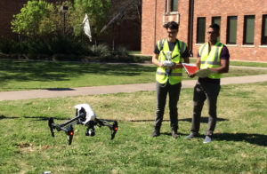
The Engineers for a Sustainable World started a campus drone mapping project on March 30 to discover the number of trees on campus. The drone took off at McCoy Engineering Hall to map the entire campus on a pre-programmed flight.
Suman Bhandari, mechanical engineering senior and ESW president, said the goal of this project was to map the entire campus to see the number of trees.
“This is the first part of the project. We are mapping the campus. In the second phase, we will plant trees wherever it’s necessary. This [mapping] will determine which locations need more trees,” said Bhandari. “For Engineers for a Sustainable World, we focus on sustainability, green and energy efficiency, so this is one of our projects for this semester.”
Michael Arthur Olaya, mechanical engineering senior and chair of projects and education, said doing projects and answering these questions are helpful in creating a better world with more sustainable things.
“I think it’s really cool to answer simple questions with non obvious answers. If I ask you how many trees are on campus, you just don’t know. If you want to effectively manage something, you have to be able to measure it. My favorite example is when this engineer, Buckminster Fuller, asked Norman Foster, an architect, how much his building weighed. He had no idea. It’s a really simple question with a non obvious answer,” Olaya said. “If we want to build sustainable things and build a better world, we have to be able to answer these questions.”
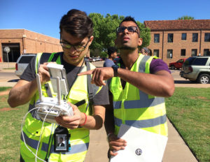
Olaya provided his drone for the project. He said drones will be used for more than just the obvious reasons in the future.
“These will be our police officers. They’ll put sensors all over the city looking for abnormalities and sounds. If it hears a gunshot, then it can send a drone out there and be constantly mapping,” Olaya said.
Baskaron Ravi Prasanth, mechanical engineering senior and ESW secretary, said they have six members in the organization and are hoping to increase the numbers. He said this club is unique because it focuses on the environment.
“There are other engineering clubs, but this one is more concerned with the environment. With anything we do, the environment has a huge role in it. That’s one of the reasons I am interested in this club. I recently became secretary, and I really enjoy it,” Prasanth said.
How many cars do you think are on @MidwesternState campus (typical Thursday @ 11AM)? Results coming soon! @WichitanOnline @bradleywilson09
— Michael Olaya (@arthurolaya) April 1, 2017
Engineers for a Sustainable World
- established 2002
- 56 chapters
- 1,500 members


Madison • Apr 7, 2017 at 1:08 PM
Why not just walk around campus with an appropriately sized map, maybe some graph paper, pencils, and count the trees? It would be cheaper than a drone, just as accurate, and get you some exercise. While the drone is cool, it’s totally unnecessary, unless you are actually mapping the branches in the trees.